English
 French
 Khmer
Khmer Thai
Thai Vietnamese
 Chinese
 Korean
 German
 Japanese
 Italian
 Russian
 Spanish
 Dutch
Dutch Indonesian
 Malay
MalayLake Austin
Lake Austin
USA
Austin
Austin Travel Guide
Book Tour & Activities
Your tour in Austin.
Book your stay
Your hotel in Austin.
Overview
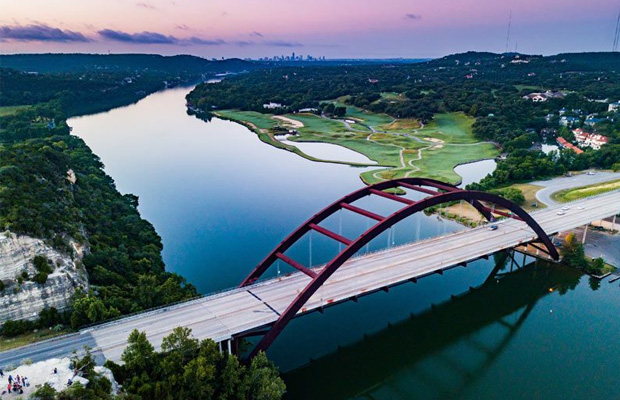
Lake Austin, formerly Lake McDonald, is a water reservoir on the Colorado River in Austin, Texas. The reservoir was formed in 1939 by the construction of Tom Miller Dam by the Lower Colorado River Authority. Lake Austin is one of the seven Highland Lakes created by the LCRA, and is used for flood control, electrical power generation, and recreation.
Lake Austin, formerly Lake McDonald, is a water reservoir on the Colorado River in Austin, Texas. The reservoir was formed in 1939 by the construction of Tom Miller Dam by the Lower Colorado River Authority. Lake Austin is one of the seven Highland Lakes created by the LCRA, and is used for flood control, electrical power generation, and recreation.
Hydrology
Lake Austin is a part of Texas' Colorado River; it begins below Mansfield Dam and is principally fed by the outflow of Lake Travis. The lake meanders generally from northwest to southeast, with few significant tributaries; the largest are Bull Creek, entering from the north near where Loop 360 spans the lake at the Pennybacker Bridge, and Bee Creek, entering from the west just above Tom Miller Dam, where the lake ends. Its outflow through Tom Miller Dam then becomes the principal inflow for Lady Bird Lake.
Lake Austin is maintained as a constant-level lake by releases of water from Lake Travis upstream. The other Highland Lake reservoirs on the Colorado River are Lake Buchanan, Inks Lake, Lake LBJ, Lake Marble Falls, and Lake Travis upstream, and Lady Bird Lake downstream.
History
The first lake on the same site was named Lake McDonald, a reservoir formed by the construction of Austin Dam between 1890 and 1893. In 1900 a heavy rainstorm overwhelmed and destroyed the first Austin Dam, causing extensive flooding. The dam began to be rebuilt in 1915, but repairs were abandoned because of a contract dispute, and the unfinished dam was again destroyed in a heavy storm later that year. In 1938 the Lower Colorado River Authority began building the Tom Miller Dam; the dam was completed and the lake filled in 1939.
Area: 6.471 km²
Surface elevation: 150 m
Max. depth: 75 ft (23 m)
Location: Austin, Texas
Video Travel Inspiration


See Lake Austin on Map
Book your best stay in Austin


Most Popular Cities

Siem Reap
Cambodia
Ho Chi Minh City
Vietnam
Beijing
China
Paris
France
London
United Kingdom
New York
USA
Tokyo
Japan
Bangkok
Thailand
Seoul
South Korea
Vientiane
Laos
Yangon
Myanmar
Washington DC
USA
Los Angeles
USA
Ottawa
Canada
New Delhi
India
Singapore
Singapore
Kuala Lumpur
Malaysia
Sydney
AustraliaPartnerships
Our teams up with big names to bring you exclusive promotions