Marin Headlands
Marin Headlands
USA
San Francisco
San Francisco Travel Guide
Book Tour & Activities
Your tour in San Francisco.
Book your stay
Your hotel in San Francisco.
Overview
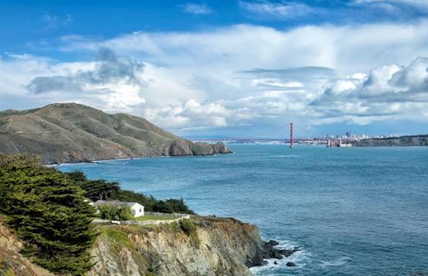
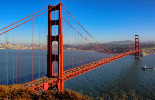
The Marin Headlands is a hilly peninsula at the southernmost end of Marin County, California, United States, located just north of San Francisco across the Golden Gate Bridge, which connects the two counties and peninsulas. The entire area is part of the Golden Gate National Recreation Area. The Headlands are famous for their views of the Bay Area, especially of the Golden Gate Bridge.
The Marin Headlands is a hilly peninsula at the southernmost end of Marin County, California, United States, located just north of San Francisco across the Golden Gate Bridge, which connects the two counties and peninsulas. The entire area is part of the Golden Gate National Recreation Area. The Headlands are famous for their views of the Bay Area, especially of the Golden Gate Bridge.
Climate
The Headlands sometimes create their own clouds when moist, warm Pacific Ocean breezes are pushed into higher, colder air, causing condensation, fog, fog drip and perhaps rain. The hills also get more precipitation than at sea level, for the same reason. However, despite being relatively wet, strong gusty Pacific winds prevent dense forests from forming. The many gaps, ridges, and valleys in the hills increase the wind speed and periodically, during powerful winter storms, these winds can reach hurricane force.[citation needed] In summer, breezes can still be very gusty, when the oceanic air and fog cross the hills.
November through February in the Headlands are dominated by periodic rainstorms that blow in from the Pacific, often originating in the Gulf of Alaska, and give the area the majority of its rainfall for the year. These cloudy, gray, and rainy days often are interspersed with cool but extremely clear ones. As winter turns to spring, the April-to-June weather tends to be dominated by powerful winds, less rain, and clearer skies. Summer days alternate between clear and warm intervals, giving way to foggy and cool periods. September and October bring the highest average temperatures of the year and the longest stretches of clear skies.
Hawk Hill
The centerpoint of the Marin Headlands skyline is the 920-foot (280 m) Hawk Hill, the lookout point for the largest known flight of diurnal raptors in the Pacific states.
Each autumn, from August into December, tens of thousands of hawks, kites, falcons, eagles, vultures, osprey, and harriers are funneled by the peninsular shape of Marin County into the headlands. Hawks avoid flight over water since warm thermals that provide lift are rare. Abundant populations of small mammals protected by the park are one resource that helps maintain the large number of visiting raptors in the Headlands during the fall, but the strong onshore winds hitting the hills of the Headlands provide cold updrafts and hot late summer days provide warm thermals that allow these birds to fly more efficiently.
Volunteers with the Golden Gate Raptor Observatory count and track this fall migration using bird-banding and radio-tracking techniques, all in cooperation with the National Park Service.
Video Travel Inspiration
See Marin Headlands on Map
Most Popular Cities

Siem Reap
Cambodia
Ho Chi Minh City
Vietnam
Beijing
China
Paris
France
London
United Kingdom
New York
USA
Tokyo
Japan
Bangkok
Thailand
Seoul
South Korea
Vientiane
Laos
Yangon
Myanmar
Washington DC
USA
Los Angeles
USA
Ottawa
Canada
New Delhi
India
Singapore
Singapore
Kuala Lumpur
Malaysia
 English
 French
 Khmer
Khmer Thai
Thai Vietnamese
 Chinese
 Korean
 German
 Japanese
 Italian
 Russian
 Spanish
 Dutch
Dutch Indonesian
 Malay
Malay
