English
 French
 Khmer
Khmer Thai
Thai Vietnamese
 Chinese
 Korean
 German
 Japanese
 Italian
 Russian
 Spanish
 Dutch
Dutch Indonesian
 Malay
MalayMuir Woods National Monument
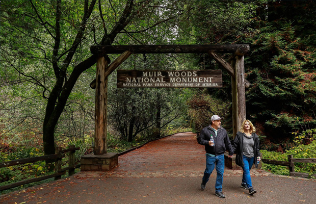
Muir Woods National Monument
USA
San Francisco
San Francisco Travel Guide
Book Tour & Activities
Your tour in San Francisco.
Book your stay
Your hotel in San Francisco.
Overview
Muir Woods National Monument is a United States National Monument managed by the National Park Service, named after naturalist John Muir. It is located on Mount Tamalpais near the Pacific coast, in southwestern Marin County, California. It is part of the Golden Gate National Recreation Area, and is 12 miles north of San Francisco. It protects 554 acres, of which 240 acres are old growth coast redwood forests, one of a few such stands remaining in the San Francisco Bay Area.
Muir Woods National Monument is a United States National Monument managed by the National Park Service, named after naturalist John Muir. It is located on Mount Tamalpais near the Pacific coast, in southwestern Marin County, California. It is part of the Golden Gate National Recreation Area, and is 12 miles north of San Francisco. It protects 554 acres, of which 240 acres are old growth coast redwood forests, one of a few such stands remaining in the San Francisco Bay Area.
Geography
Ecosystem
The Muir Woods National Monument is an old-growth coastal redwood forest. Due to its proximity to the Pacific Ocean, the forest is regularly shrouded in a coastal marine layer fog, contributing to a wet environment that encourages vigorous plant growth. The fog is also vital for the growth of the redwoods as they use moisture from the fog during droughty seasons, in particular the dry summer.
Climate
The monument is cool and moist year round with average daytime temperatures between 40 and 70 degrees Fahrenheit (4 to 21 °C). Rainfall is heavy during the winter and summers are almost completely dry with the exception of fog drip caused by the fog passing through the trees. Annual precipitation in the park ranges from 39.4 inches (1,000 mm) in the lower valley to 47.2 inches (1,200 mm) higher up in the mountain slopes.
Soils and bedrock
The redwoods grow on brown humus-rich loam which may be gravelly, stony or somewhat sandy. This soil has been assigned to the Centissima series, which is always found on sloping ground. It is well drained, moderately deep, and slightly to moderately acidic. It has developed from a mélange in the Franciscan Formation.[8] More open areas of the park have shallow gravelly loam of the Barnabe series, or deep hard loam of the Cronkhite series.
Address: Mill Valley, CA 94941, United States
Visitors: 957,932 (in 2018)
Reference no: 07001396
Established: January 9, 1908
Management: National Park Service
Video Travel Inspiration


See Muir Woods National Monument on Map
Book your best stay in San Francisco


Most Popular Cities

Siem Reap
Cambodia
Ho Chi Minh City
Vietnam
Beijing
China
Paris
France
London
United Kingdom
New York
USA
Tokyo
Japan
Bangkok
Thailand
Seoul
South Korea
Vientiane
Laos
Yangon
Myanmar
Washington DC
USA
Los Angeles
USA
Ottawa
Canada
New Delhi
India
Singapore
Singapore
Kuala Lumpur
Malaysia
Sydney
AustraliaPartnerships
Our teams up with big names to bring you exclusive promotions